

Mount Sherman
Date to Climb: June 22, 2009
Date Climbed: June 11, 2009
Elevation: 14,036
Range: Mosquito
Latitude: 39.22490, Longitude: -106.16980
Route: West Slope l, Class 2
Round-Trip Mileage: 4.5
Pre-Climb Comments
We are hoping to do the West Slopes from Iowa Gulch, the Leadville side. Depending on what is happening with Holy Cross we might need to do Sherman earlier to have another day off. At some point we will need to shop, shower, suds. We are expecting this to be an easy day in the mountains.
Post-Climb Comments
We used Sherman as an acclimating hike. See Acclimating - Mountain Hike.
Leaving from the Iowa Gulch Trailhead at 9:30 we began the climb. We packed a little extra clothes due to the possible conditions.
A couple and their dog met us not long after we began. They had turned back from the climb due to the conditions, ’you could not see a thing.’
Not discouraged we continued up Iowa Gulch to the pass separating Sherman and Sheridan. A solo hiker breezed by us as we plodded along. At the pass he introduced himself as Clay and though he had lived his whole life in Leadville, he had never climbed a fourteener. He was in good shape and carried a big smile. As we tended to some household chores, Clay left for his summit bid.
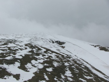
Heading up the ridge on Sherman
We met him again a few hundred feet up the ridge, he had decided to descend, the weather was just too tough. We invited him to join us. He gratefully accepted.
The higher we climbed the harder the wind blew. Rain, sleet, and snow belted us. My camera and GPS case was flying at a ninety degree angle. Our trekking poles were blown sideways so that we had difficulty placing them. All of our clothes flapped in the wind. The batteries went out on the GPS and we had to replace them bare handed. Jake, the dog, looked like a big snow ball, which delayed us as we had to stop to clear the ice and warm him. Visibility dropped to a few feet in places. My sunglasses were cover in ice and I had to take them off to try to see, exposing my eyes to the furor of the storm. The ridge had a huge cornice which made us climb on the exposed windward side. We wanted to put on additional clothes, but couldn't figure out how to do add the layers in the wind. Amy was blown down or over twice! She was afraid she was going to be blown over the ridge. Clay, who did not have poles, constantly had to bend over and touch the ground for stability.
Finally the GPS announced we were on the top. I hunkered down with Jake and waited on Clay and Amy to arrive. Clay took pictures. I had stolen the batteries from Amy's camera for the GPS and my camera would have to be used bare handed. We did not take a single picture of the upper mountain. We regret not taking pictures now, but it was not part of our survival instincts.
Amy said Clay took pictures the whole way up the ridge. He even took videos and gave a commentary!
Soon as we touched the top, we headed down the ridge as quickly as possible. It was not long until we hit the pass and then the trail again. Our hands finally unthawed. They had been blocks of wood for almost the entire time on the ridge.
Clay parted ways with us and thanked us for letting him join us. We were afraid he was going to kill us for the could-have-been lethal invitation. He scurried on down the path as we plodded along. He never complained and was a great guy to have along. I wonder if he will ever do another fourteener.
Back at the trailhead, it took us almost exactly four hours for the round trip. We were actually surprised as it seemed as if we were on the ridge for an endless amount of time.
Mount Sherman is one of the easiest of the mountains, but under those conditions, we don't see any others that we might attempt being any harder. We will not do another summit under those conditions, without purchasing full on winter gear.
Oh, we don't know how hard the wind was blowing, but it was a continuous blast of fifty to sixty miles per hour, with gusts that seemed twice as strong. The Beaufort Wind Scale would back our guesstimates.
A note to Jamie, Wendi, and Ray: the wind was at least twice as strong as on top of Rainier!
Mount Sherman - June 11, 2009 ![]()