

Montgomery Bell Trail, page 2
Trail Notes
The Park Office, Ranger Station, and/or Visitors Center is a great place to stop for general information about the Park. Overnight permits may be obtained at the office.
The only place designated for overnight parking is the Maintenance Building (or Warehouse.)
The old Visitors Center is the flagstone building on the left as you enter the Park.
The Montgomery Bell Trail is blazed white. The Creech Hollow trail is blazed orange. The Wildcat Trail is blazed blue. And the Ore Pits Trail is blazed red.
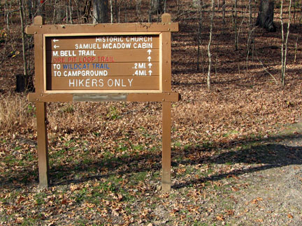
There also were a lot of signs. For some reason the east section of the trail had more mileage signs than the west section.
Several loops may be made by linking different trails.
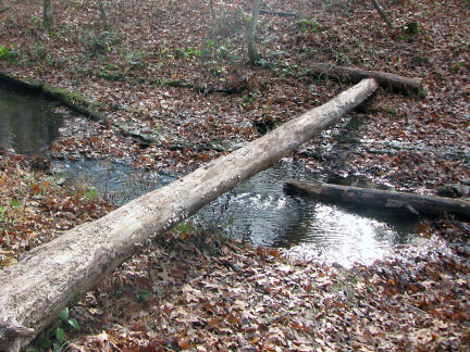
Several creek crossings did not have bridges.
In the fall, the leaves are so deep that they conceal the trail. A sea of oak leafs were knee deep in places and left the trail indistinguishable. Jake used his nose to keep us on the right path. We were just lucky a varmint had not passed that way recently, no telling where we would have ended up.
The road along the south edge of the golf course ran out of discernible blazes. The road was so easy to follow, who would need a blaze? Well, as my mind was wandering, I wondered if I had missed the trail junction. There was no need to worry though, the intersection was a very obvious, well signed, turn to the right.
It is .30 miles from the trail to Woodland Shelter. It is set in a scenic position, but the trail seems to wander.
Shortly after the point on Lake Woodhaven there was a boardwalk that went to the right of the path. The boardwalk was not on any maps and was not signed. It was just there. I later read that it was a walkway intended to observe the wet lands.
The Montgomery Bell Trail basically follows the Park boundary. Developments are however encroaching on all sides of the Park. If the trails could be moved more toward the interior of the Park the view shed would be improved and the trail would have more of a wilderness feel.
Water and restrooms are available at the Visitors Center. For that matter, the Park also has a campground, inn, and restaurant. All the facilities were well maintained.
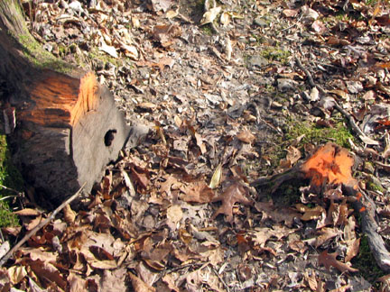
Oddly enough, someone had painted possible trail hazards orange. There were hundreds of roots, rocks, and stumps covered with an orange coating of paint. I wondered what criteria they used to qualify an obstruction as being a hazard.
The Montgomery Bell Trail is a worthy hike for anyone looking for a longer day hike or overnight trek.
The mileages will be for the Montgomery Bell Trail, the East Loop Trail, and the West Loop Trail.
The East Loop Trail would be at shorter, if you parked at the Park Office (Ranger Station) or at the first picnic area on the left off Hotel Road.
Montgomery Bell Trail Mileage
.00 to .07 Parking to bridge
.07 to .50 Bridge to crossing Jackson Hill Rd
.50 to .60 Crossing to junction with Creech Hollow
.60 to .90 Junction to top of stairs
.90 to 1.15 Stairs to crossing Hotel Rd
1.15 to 1.25 Crossing to trail sign at entrance
1.25 to 2.00 Sign to top of hill
2.00 to 2.35 Top of hill to start of descent
2.35 to 2.75 Descent to shelter
2.75 to 3.25 From shelter along creek
3.25 to 3.75 Creek to road behind golf course
3.75 to 4.80 Road to turn off
4.80 to 5.35 Road turn off to junction Creech Hollow
5.35 to 5.70 Junction to crossing Jackson Hill Rd
5.70 to 6.00 Road to junction Woodland Spur
6.00 to 6.90 Junction to Point on Lake Woodhaven
6.90 to 7.15 Point to boardwalk
7.15 to 7.35 Boardwalk to Hall Shelter
7.35 to 7.70 Shelter to Hall Cemetery Rd
7.70 to 8.30 Road to day shelter
8.30 to 9.10 Day shelter to McAdow Cabin
9.10 to 9.40 McAdow Cabin to top of hill
9.40 to 10.00 Top of hill road crossing and picnic grounds
10.00 to 10.25 Picnic Grounds to Group Camp 1 Rd
10.25 to 10.35 Road to Parking Area
East Loop Trail Mileage
.00 to .07 Parking to bridge
.07 to .50 Bridge to crossing Jackson Hill Rd
.50 to .60 Crossing to north junction with Creech Hollow
.60 to .90 Junction to top of stairs
.90 to 1.15 Stairs to crossing Hotel Rd
1.15 to 1.25 Crossing to trail sign at entrance
1.25 to 2.00 Sign to top of hill
2.00 to 2.35 Top of hill to start of descent
2.35 to 2.75 Descent to shelter
2.75 to 3.25 From shelter along creek
3.25 to 3.75 Creek to road behind golf course
3.75 to 4.80 Road to turn off
4.80 to 5.35 Road turn off to south junction with Creech Hollow
5.35 to 5.90 Junction to Creech Hollow Lake Dam
5.90 to 6.50 Dam to north junction with MB Trail
6.50 to 6.60 Junction to Jackson Hill Rd crossing
6.60 to 7.10 Road to Parking Area
West Loop Trail Mileage
.00 to .07 Parking to bridge
.07 to .50 Bridge to crossing Jackson Hill Rd
.50 to .60 Crossing to north junction with Creech Hollow
.60 to 1.20 Junction to Creech Hollow Lake Dam
1.20 to 1.75 Dam to south junction with MB Trail
1.75 to 2.10 Junction to crossing Jackson Hill Rd
2.10 to 2.40 Road to junction Woodland Spur
2.40 to 3.30 Junction to Point on Lake Woodhaven
3.30 to 3.55 Point to boardwalk
3.55 to 3.90 Boardwalk to Hall Shelter
3.90 to 4.25 Shelter to Hall Cemetery Rd
4.25 to 4.85 Road to day shelter
4.85 to 5.65 Day shelter to McAdow Cabin
5.65 to 6.00 McAdow Cabin to top of hill
6.00 to 6.30 Top of hill to day shelter
6.30 to 6.55 Day shelter to road crossing and picnic grounds
6.55 to 6.80 Picnic Grounds to Group Camp 1 Rd
6.80 to 6.90 Road to Parking Area
Map Link
The link opens in a new window.
Montgomery Bell Park Trails - pdf
GPS
Control Click or Right Click for download.
Montgomery Bell Park in Text Format - mBellTL.txt
Montgomery Bell Park in GPX Format - mBellTL.gpx
Montgomery Bell Park in KML Format - mBellTL.kml