

Alum Cave Trail - Mt Le Conte - page 2
Hiking Notes
For most hikers an ascent of Mount Le Conte, with perfect weather, is a challenging goal. This mountain deserves respect.
The Alum Cave Trailhead is well signed. It is located on Hwy 441.
A new privy is located in the lower parking area (the first one you reach when approaching from Sugarlands Visitors Center).
The parking area does fill up.
There is no water at the trailhead. Water is available at Sugarlands Visitors Center.
Water is available at the Mount Le Conte Lodge, but only during warmer weather. There is also a spring located near the Lodge off the Trillium Gap Trail. Water is also available along the Alum Cave Trail. All the water from the spring or along the trail would need to be treated, filtered, or both.
Check with Mount Le Conte Lodge for services, prices, and the dates of the operating season.
Please respect the Lodge - the workers, guests, and the facilities.
On a recent trip to Le Conte, after filtering water from the spring, I stopped by the privy in the Lodge area. To my surprise the housekeeping of the facility was impeccable. That outhouse deserved a 5 star rating! Thanks caretakers - great job!
The trail is not marked with blazes, but it is easy to follow. Trail signs are at every junction.
On popular weekends, the trail can be very busy. If you are looking for solitude, try Bullhead Trail.
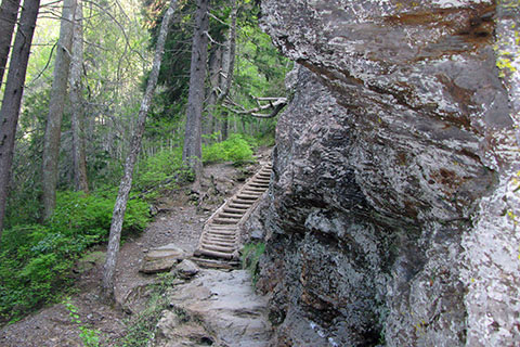
Most of the grade of the trail is just moderate with a few steeper short sections mostly climbed with steps of some sort. There is a lot of moderate climbing though and also sections of the trail has difficult footing. The overall trail is rated as difficult.
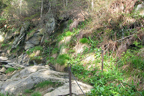
Wire rope handrails help to safe guard rocky sections of the trail.
The mountain is climbed by adventurous hikers in all seasons and in all weathers. Some hikers just wait for the gnarly weather before they attempt a climb.
In the winter the handrails help tame the treacherous snow and ice covered rocks.
Mount Le Conte is a big mountain. In the winter it is cold, windy, and wet. In the other seasons, the mountain is colder, more windy, and wetter than the land 3,000 feet below.
The Lodge is not open in the winter.
In the summer, the trail is mostly shaded, but it can be hot and humid.
Expect wetness (rain, sleet, snow) on your hike.
Don't forget to carry the essentials - map, water, food, rain gear, insulation layer, first aid kit, and other emergency gear.
Have a plan and a backup for refilling your water supply.
Consult the map for other trails.
Please practice minimum impact usage.
Alum Cave Trail Mileage
0.00 Alum Cave Trailhead on Hwy 441
1.40 Arch Rock at 3rd crossing of Styx Branch
2.00 Inspiration Point
2.30 Alum Cave
3.05 Log Steps - steps cut in a log with handrail
3.75 Upper Steps Switchback - at the switchback a steep set of steps with a handrail
5.00 Junction with Rainbow Falls Trail - The end of the Alum Cave Trail. To continue to the Lodge or summit - turn right.
5.10 Junction with Trillium Gap Trail - Le Conte Lodge is before the junction
5.45 High Top, the summit marked by a summit cairn - a stack of rocks
Mileage is for a one way trip.
Map Link
The link opens in a new window.
Mount Le Conte Trail Map - pdf
GPS
Control Click or Right Click for download.
Alum Cave Trail in Text Format - alumCaveTr.txt
Alum Cave Trail in GPX Format - alumCaveTr.gpx
Alum Cave Trai in KML Format - alumCaveTr.kml