

Onahu Creek - Green Mountain Loop - Rocky Mountain National Park - page 2
Onahu Creek Trail
Route Notes
The Onahu Creek Trail - Green Mountain Trail Loop is a key trail system located on the west side of the Continental Divide - near Grand Lake, CO.
For hiking the Onahu Creek Trail - Green Mountain Trail Loop you may use either trailhead - the Green Mountain or Onahu Creek. Green Mountain does have a privy and more parking.
The trails in the Park do not use (painted) blazes. There are however, directional signs at each junction. The trails are easy to follow.
The Onahu Creek Trail - Green Mountain Trail Loop is an easy day hike or can be made as a backpacking route.
The Green Mountain Trail connects with the Tonahutu Creek Trail.
For destinations in the Upper Tonahutu - Big Meadow, Granite Cascades, Haynach Lake, etc - starting at the Green Mountain Trailhead instead of the Tonahutu Creek Trailhead shortens the route by 2.50 miles.
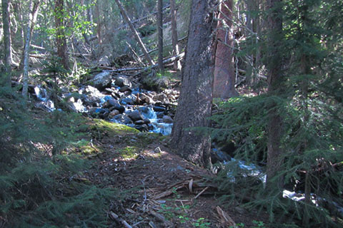
Cascading Onahu Creek, above the bridge
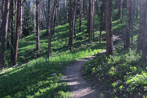
The Onahu Creek Trail is one of the best low elevation trails in the Park. It only climbs a little over a thousand feet in 7.60 miles.
The Onahu Creek Trail curves, dips, contours, climbs up the Onahu Creek drainage. It then descends to the Tonahutu Creek Trail at the upper end of Big Meadow. It is a well designed trail and a great route.
The campsites on the Onahu Creek Trail are all good. We did not do an overnight hike, but the sites looked inviting. We especially liked the (lowest) Onahu Creek Campsite.
There is only one campsite on the Green Mountain Trail - Green Mountain site. There are other sites near the Green Mountain - Tonahutu Creek Trail Junction and not far from the Onahu Creek - Tonahutu Creek Trail Junction.
Overnight permits are required for backcountry camping in the Park. The permits are available at the Kawuneeche Visitor Center, but popular sites seem to be reserved long before the summer season.
The Backcountry Office Staff have Park trail information and are able to give recommendations.
If we were able to visit the Park in a drier season, we would love to hike through Long Meadow to Timber Creek, and then travel to Timber Lake.
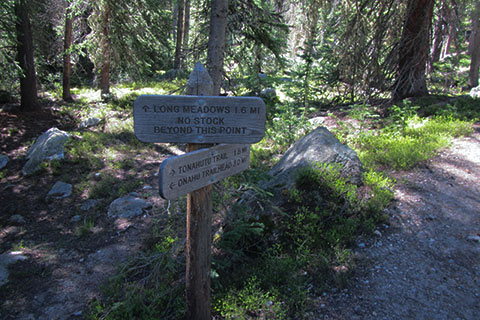
Long Meadow Trail Sign
Onahu Creek was big (lots of snow melt) when we hiked the trail.
Big Meadow is a big, flat, grassy meadow.
There are two cabin ruins just off the trail. Be careful investigating the cabins. They are ruins - meaning they are no longer structurally sound.
The route would make a good trail run.
Some of the mileages we use on cloudhiking may be slightly off the mark. We try to be as accurate as possible. We hike the trails and notice when things are not right.
The 0.25 mile red dots on the trail track line gives the hiker a scale on all parts of the trail. It is easy to calculate a rough estimate of the distance to any location on the trail. It is also comforting to know that the scale is the same throughout the map. In other words 0.25 mile at one point on the map is .25 mile at all other points of the map!
For the first time on the Loop Map, we started adding green arrows and a distance (green) to signify the distance between a red dot and the end of the section. For example, if the green distance between the final red dot and red star (indicating a waypoint and the end of the segment) was a fraction of the quarter of a mile segment, the green distance would give the determined distance.
Note: red dots on the trail track line are reset at each trail junction.
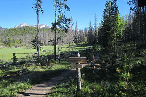
Mileage sign near Onahu Creek Trailhead
For Mountain Data and Route Guide
go to Page
1
Onahu Creek - Green Mountain Loop Trail Mileage
0.00 Green Mountain Trailhead
0.70 Onahu Creek Trailhead
0.85 Bowen Gulch Junction
1.30 Footbridge over small creek
2.05 Lower Onahu Creek Bridge (1st)
2.65 Onahu Creek Campsite
3.60 Onahu Creek Bridge (2nd)
5.20 Onahu Creek - Tonahutu Creek Trail Junction
5.80 Tonahutu Creek - Green Mountain Trail Junction
7.60 Green Mountain Trailhead
Map Link
The link opens in a new window.
RMNP - west - The Loop - North Inlet, Tonahutu Creek , and other Trails - pdf
RMNP - west - The Loop - North Inlet, Tonahutu Creek , and other Trails - geospatial pdf