

Mount Elbert - South Mount Elbert Trail - East Ridge
Route Notes
The Lower South Mount Elbert Trailhead is accessible by automobiles. From the Lower Trailhead, it is 1.8 miles by the 4WD road to the Upper Trailhead.
The Lower Trailhead is located just above the National Forest Service's Lakeview Campground. Reservations for campsites may be made through 'reserve america'.
Camping might also be available along the 4WD road and near the Upper Trailhead. Some of these free sites are better than others.
At the Upper Trailhead there is a Trail Kiosk. That's about all.
The South Elbert Trail and North Elbert Trail made the map of the South Mount Elbert Trail Kiosk. (At the North Trailhead the North Elbert Trail was not indicated on the map.)
The only easily available water that we passed was the creek at the trailhead. The water would definitely need treating.
Some older guide book descriptions have the South Elbert Trail - Colorado Trail Junction just passed the creek, near the trailhead. The current trailhead is about 0.30 mile north on the Colorado Trail.
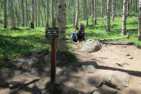
The South Elbert Trail - Colorado Trail Junction is clearly marked.
Like the North Elbert Trail, the South Elbert Trail climbs steeply through the woods. We passed a hiker who was having significant troubles descending the trail.
Trekking poles are handy for either trail.
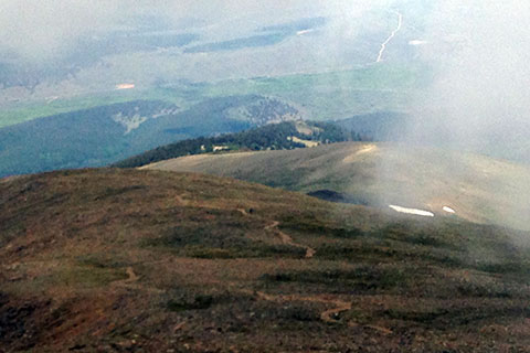
At tree-line it is a good time to check the weather. Most of the route can be seen from this point, including the snow cover.
Above tree-line it may be windy and much colder than below. Don't be surprised, pack extra clothing.
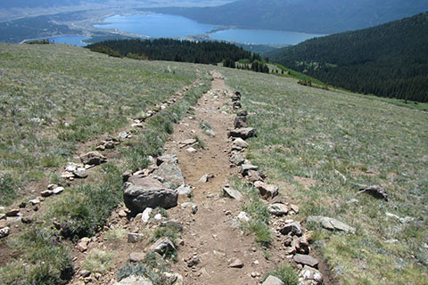
Above tree-line the trail instead of being a single track, it has expanded to many lanes of impact. For minimum impact usage - stay on the single track (the alpine tundra damages easily and repairs slowly), limit group size (large groups like walking side by side so they can talk, they like stopping to regroup and rest - but there is never a spot big enough for a large group to stop and stay off the pristine tundra, and it is difficult to pass or meet a large group), if the trail is muddy then get your feet muddy or turn around (where you make your footsteps makes a difference), don't make a new track for any reason (if you have to get off the trail use rocks as stepping stones, etc, to avoid stepping on the tundra), and support the CFI.
Once gaining the East Ridge, it is two miles to the top.
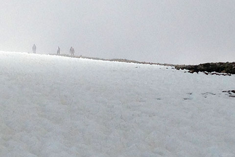
We had a rather large snowfield covering the south face and upper East Ridge. The route had more snow than the Northeast Ridge.
We met a couple on the summit who lost the trail due to the snow and had wandered across the South Face looking for the route.
The grade of the trail stays mostly even for the duration of the trail above tree-line.
There are no false summits on the route. Once at the saddle and the junction with the North Elbert Trail, it is but a short walk along the ridge to the summit.
Make an alpine start to avoid a crowded summit and afternoon thunderstorms.
Check the hourly weather forecasts. Know how fast you can walk at the grade and elevation of the intended trail. Estimate the time you should reach the summit and then return to tree-line. Start early enough to provide a margin of good weather.
Every hike we have made on Elbert we have seen a disproportionate number of struggling hikers. Elbert may not be technically difficult, but it is a steep 14,000 feet climb. Respect the mountain. Train and acclimate before attempting the climb.
Can't decide which route to do - North Mount Elbert Trail or South Mount Elbert Trail? Well, you could do both. Climb one route, descend the other, and then link the two via the Colorado Trail.
For Mountain Data and Route Guide
go to Page
1
South Mount Elbert Trail Mileage
0.00 South Trailhead (at end of 4WD road)
0.30 Junction South Mount Elbert Trail
1.60 Treeline
2.20 East Ridge
2.50 Lone Boulder
3.40 Leave East Ridge - begin traverse
3.90 End South Face Traverse - begin climb
4.20 Summit Mount Elbert - 14,433’
note: if starting from the Lakeview Campground Trailhead
and walking the 4WD road, add 1.85 miles each way
Map Link
The link opens in a new window.
Mount Elbert - pdf
Mount Elbert - geo-pdf (to use with geo-pdf reader)